
Islands of Cíes
Discover the incredible Terrestrial Maritime National Park of the Atlantic Islands of Galicia.
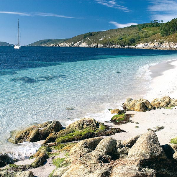
One of the most visited places in Galicia are the Cíes Islands. In any national and international travel guide, a must-see attraction for those visiting Vigo and the Rias Baixas is visiting the Cíes Islands, an authentic natural space well known for its crystalline water and white sand beaches surrounded by nature.
During the summer months, the islands reach their maximum allowed capacity with a very limited number of visitors. Therefore, it is advisable to book your tickets at least 30 days in advance of the date you plan to visit.
Discover the island
World Heritage Site
Cíes Islands Candidacy for Unesco World Heritage Site
The Cíes Islands have been a candidate for Unesco World Heritage Site since 2017. A distinction that seeks to recognise places on Earth with exceptional universal value. The current list of World Heritage Sites has more than 1,200 places all over the planet, of which more than 200 are of a natural nature, such as the Great Barrier Reef (Australia), the Fjords (Norway) or the Doñana National Park (Spain).
Criteria for the Cíes Islands to become a World Heritage Site
Criteria for the Cíes Islands to become a World Heritage SiteThe criteria for a natural property to be eligible for nomination are diverse. Here we explain why the Cíes Islands should be a World Heritage Site:
With regard to the fauna, there are thousands of birds that have their own habitat on the islands (shag, gulls, peregrine falcon or goshawk, among others).
It also has flora that can only be found in this environment: herba de Namorar or camariña, plants that inhabit dunes and cliffs.
The marine area surrounding the archipelago is one of the richest on the Galician coast, with fauna and flora specific to the ecosystem: barnacles, lobsters, octopus, forests of anemones, sea urchins, bream, otters and starfish are some of the marine organisms that live under its waters. Dolphins, whales and sea turtles are also regular visitors to the Cíes.
The fact that it is a World Heritage Site allows for better protection and conservation of this natural space.
The Cíes Islands have a sub-humid Mediterranean microclimate of Atlantic transition: it rains half as much in the archipelago as on the nearest coast, just 10 kilometres away.
The Cíes Islands have been a candidate for Unesco World Heritage Site since 2017. A distinction that seeks to recognise places on Earth with exceptional universal value. The current list of World Heritage Sites has more than 1,200 places all over the planet, of which more than 200 are of a natural nature, such as the Great Barrier Reef (Australia), the Fjords (Norway) or the Doñana National Park (Spain).
Don't miss it
Get to know the biggest secret of the Rías Baixas
Cíes Islands Camping
The Cíes Islandscampsite offers a wide variety of services that will make your stay an unforgettable experience. You can choose between bringing your own tent or renting one beforehand on the campsite's website..

If you opt for a rental tent you should know that, at the moment, the number of tents is limited so it is advisable to book in advance. You will be allocated tents in order of booking. The tents in the front row are allocated to those booked first. As a camper, you can bring your own bag or blanket or rent one through the campsite's booking system, as well as a torch, as the pitches do not have electricity and power sockets.
Before booking the rental tents it is necessary to check their availability through the booking form available at campingislascies.com. The rental of the tent and beds is for a minimum of two nights.
Photo gallery
Discover the natural beauty of Cíes Islands through our photo gallery.
Discover our gallery of photographs of the Cíes Islands and know through our images the nature, fauna, beaches and landscapes of these unique islands in the world.
![]() AUTHORISATION
AUTHORISATION
To access the Cíes Islands, in addition to buying the boat tickets that will take you to the island on a pleasant crossing, you must have the authorisation of the Xunta de Galicia (Galician Regional Government). This body controls access to the island, as it is a National Park, and ensures that the white sandy beaches and crystal-clear water and unparalleled scenery remain intact. You must plan your visit well and carry out a series of very simple bureaucratic steps beforehand.